2024
synergies with H2020/HEU
digital tools
e-learning
big data

The CAP 2023-2027 emphasizes sustainability and climate mitigation to tackle environmental challenges and conserve biodiversity, by including taking advantage of climate-smart technologies.
On this regard, the role of the Agricultural Knowledge and Innovation Systems (AKIS) and, specifically of the advice, is crucial to conjugate the modernisation of the agricultural sector and rural areas with the environmental care and climate change mitigation, to ensure a system perspective, a collaborative research and innovation pathways and a digitalization of the agricultural sector that are likely to address tailored and context-sensitive opportunities of a sustainable development.
Among the others, EU programmes and digital platforms (e.g. Copernicus, Galileo) include large datasets from satellites, drones, sensors and GPS, along with from in situ sources that represent valuable and on time information on, for example, soil health, weather conditions and crop performance, and have the enormous potential for sustainability and environmental monitoring (e.g. biodiversity, carbon footprints, and compliance with environmental standards) and for data-driven decision-making of farmers to meet CAP's sustainability goals.
Particularly, they have the potential to support better planning, monitoring, and risk management, and optimizing farming processes like irrigation, fertilization, and pest control, improving yields while reducing resource use.
On this regard, the CAP networks can support the AKIS pursuing these important CAP objectives, through systematizing the different sources and infrastructures of knowledge and encouraging the widespread of use of digital tools by facilitating the interactions among the actors and contributing to their capacity development.
However, in Italy, the level of access and adoption of digital technologies by farms is still unsatisfactory due the costs, the scarce information and tools tailored to the needs and specificities of the territories and of the insufficient incentives on investments and of digital skills and tools of advisors and of difficulties with digital infrastructures in remote and marginal areas.
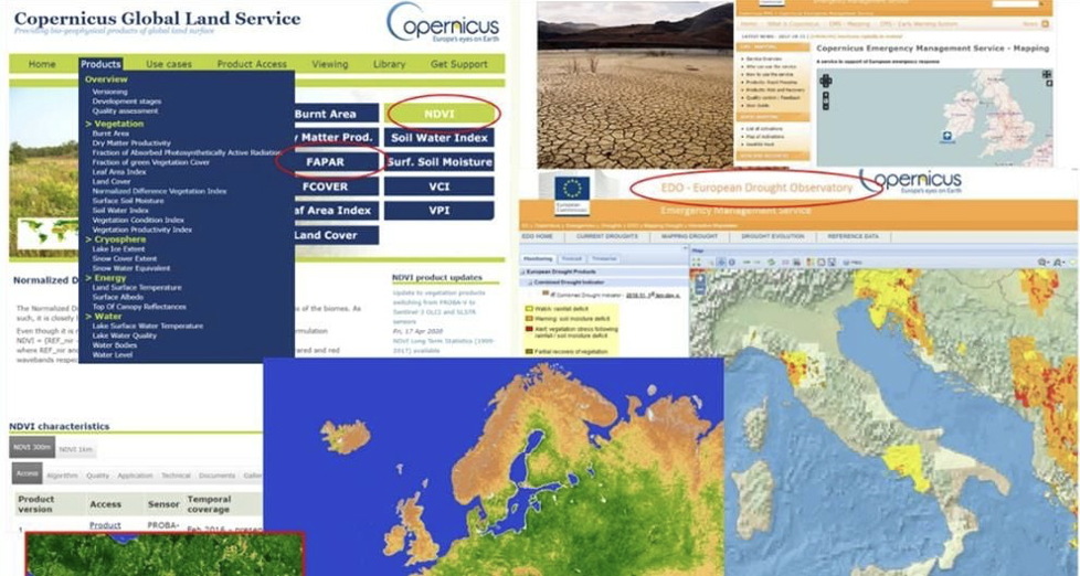
Copernicus, the Earth observation component of the EU’s Space Programme, provides free and accessible data from satellites and in situ sources to monitor the planet and its environment. Managed by the European Commission, it helps improve quality of life by offering valuable information to service providers, public authorities, and organizations. In agriculture, Copernicus plays a key role in advisory services by providing real- time data on soil, crops, weather, and environmental changes. This enables farmers to optimize resource use, improve yields, and adopt sustainable practices, making it essential for precision agriculture and reducing environmental impact. The services provided by Copernicus platform include:
- Copernicus Atmosphere Monitoring Service (CAMS).
- Copernicus Marine Service.
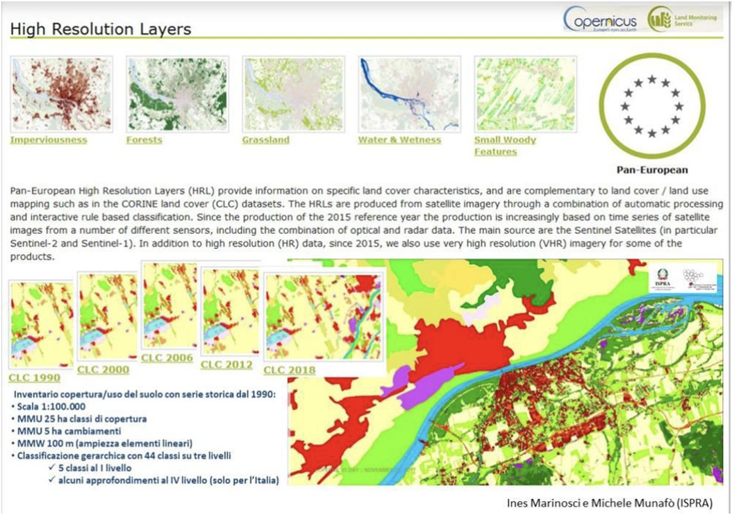
- Copernicus Land Monitoring Service (CLMS).
- Copernicus Climate Change Service (C3S).
- Copernicus service for Security applications.
- Copernicus Emergency Management Service (Copernicus EMS).
The Copernicus Academy is the network established y the European Commission as part of the Space Strategy for Europe, that connects universities, research institutions, business schools, and organizations across Copernicus Participating Countries and beyond. Its goal is to link academia with authorities and service providers, promote collaborative research, and develop educational resources such as lectures, training sessions, and internships. The Academy aims to equip the next generation of researchers, scientists, and entrepreneurs with the skills needed to fully utilize Copernicus data and services.
The managing authority of the NRN programme established the project entitled “ISMEA Copernicus Academy for the National Rural Network", that developed the format for training courses to be conducted at regional level on the European Earth Observation Programme Copernicus to inform and develop capacities on the Copernicus platform for its use of tool for the provision of services aiming at improving innovativeness and sustainability of farms in the territories.
ISMEA – Institute of services for the agricultural food market, is partner of the Copernicus Academy and of the NRN.
The project is implemented through local "Open Schools" that are shaped by a network model, promoting cooperation and skills in the specific area, by engaging managing authorities of the rural development plans, agencies for environmental protection (ARPA), firms having a specific Copernicus expertise, advisors and farms, research and academic bodies and the National Coordination of the Copernicus Academy.
The format includes the engagement of partners of relevant national and Horizon projects (e.g. LANDSUPPORT) as trainers, with the aim of exploring opportunities to put these projects into practical application.
At first two open schools were realized as pilots at regional level: Region Campania and Region Veneto.
ISMEA Copernicus Academy is coordinated at national level and it is advertised by webinars, articles on the NRN magazine and informative videos.
At national level, ISMEA Copernicus Academy set the framework for the organization of the open schools in the territories, by including:
Furthermore, the project foresees the setting up of a MOOC platform, to support the systematization at national level of didactical materials and continuous training of advisors on the different topics.
In view to activate the open schools at regional level, local committees are set up in regions to engage institutional and practitioner relevant actors in their organization.
The learning agenda is based on a virtuous path of needs assessment of the farms and offer of competences on specific topics relating to earth observation, geoinformation and ICT.
The training agenda is structured around four days and organized to provide sensibilization and awareness among advisors on the use of digital tools for supporting more sustainable practices in farming systems, along with training on their availability and possible joint use of agronomic knowledge with earth observation and georeferencing information on land three days of full training and one day of open discussion between trainers and trainees, with the view to reflect on lessons learned and apply Copernicus at local level to provide relevant advisory services to farms (box 2).
Certificates of full attendance are delivered under the condition of a full participation to all the 4 training days as well as training credits to professional advisors.
Figure 2: Servizi di informazione basati sull'osservazione satellitare della Terra e dati in situ (non spaziali)
Box 1: Training agenda
The training agenda is structured around three main points:
By exploiting the information assets and know-how of local and national competence centres and promoting the databases and information and methodologies made available by the EU's Copernicus Programme, the project creates a favourable environment for the promotion and development of back-office services advocated by the CAP.
Specific benefits highlighted for this practice are: